Update: 10:10 p.m. - Fire jumps Foresthill Divide Road, grows to nearly 10,000 acres
The American Fire, burning in heavy fuels on very steep slopes about eight miles from the community of Foresthill, has grown to 9,726 acres. Today the fire crossed the Foresthill Divide Road into the Whisky Hill area.
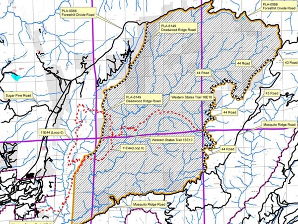
An emergency closure order remains in place for portions of National Forest System lands within and adjacent to the American Fire. A map and description of the closed area can be obtained at Tahoe National Forest offices as well as online athttp://www.fs.usda.gov/tahoe
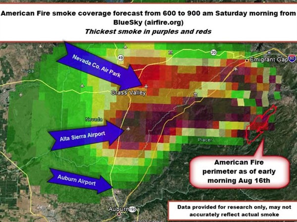
Heavy fuels are creating large amounts of smoke, which is a significant issue for the Sierra Foothills, Tahoe area, and Sacramento Valley. Several counties have issued air quality warnings, and those planning to visit area campgrounds and other recreation sites may experience intermittent heavy smoke.
Smoky conditions may last for several days. Changing weather patterns are likely to affect fire behavior and smoke dispersal patterns.

Fire officials established an incident base known as a spike camp in the Greek Store area off of Mosquito Ridge Road to enable easier access to the southeast end of the fire.
A 10,000 gallon water tank and a 10,000 gallon mobile retardant plant to aid with helicopter suppression operations has been established at the Blue Canyon Airport just south of Interstate 80.
No populated areas are threatened, including the Foresthill community, and full suppression efforts remain in progress. Firefighter and public safety remain the highest priority.
Update: 1:00 p.m. - More Resources Dedicated to American Fire, Areas Closed
An emergency closure order is in place for portions of National Forest System lands within and adjacent to the American Fire. The fire is burning in heavy fuels, on very steep slopes. Access to the fire area is limited.
Closure map:

A 10,000 gallon water tank and a 10,000 gallon mobile retardant plant to aid with helicopter suppression operations has been established at the Blue Canyon Airport just south of Interstate 80.
The heavy fuels are creating large amounts of smoke. Smoke is a significant issue for the Sierra Foothills, Tahoe area, and Sacramento Valley. An air quality warning has been issued for Placer county. Those planning to visit area campgrounds and other recreation sites may experience intermittent heavy smoke. Smoky conditions may last for several days.
Fire officials are establishing an incident base known as a spike camp in the Greek Store area off of Mosquito Ridge Road to enable easier access to the southeast end of the fire.
The fire is located about 10 miles northeast of Foresthill in the Tahoe National Forest. The fire has burned across the North Fork Middle Fork American River and is burning both up and down the river drainage. Last night the fire moved up Secret Canyon to Ford Point. The potential for fire growth is high due to the heavy fuels and steep slopes (up to 150 percent). One mining structure was destroyed and there have been two minor injuries todate.
The community of Foresthill is not threatened.
A map and description of the closed area can be obtained at Tahoe National Forest offices as well as online at
http://www.fs.usda.gov/tahoe
Fire perimeter as of Friday morning in red:
Basic Information
| Incident Type |
Wildfire |
|---|
| Cause |
Under Investigation |
|---|
| Date of Origin |
Saturday August 10th, 2013 approx. 04:30 PM |
|---|
| Location |
Deadwood Ridge, northeast of Foresthill |
|---|
| Incident Commander |
Dana D'andrea |
|---|
Current Situation
| Total Personnel |
1,226 |
|---|
| Size |
7,367 acres |
|---|
| Percent Contained |
31% |
|---|
| Fuels Involved |
Heavy timber
|
|---|
| Fire Behavior |
The fire will continue to grow today. It is currently moving toward the American Hill Road moving roughly northeast. The alignment of topography and the predicted weather pattern are contributing to fire movement.
|
|---|
| Significant Events |
Smoke is anticipated to be a significant issue for the Sierra Foothills.
|
|---|
Outlook
| Terrain Difficulty |
Very steep terrain
|
|---|
| Remarks |
Continue to fight aggressively with direct and indirect lines.
|
|---|
Current Weather
| Wind Conditions |
7-15 mph NE |
|---|
| Temperature |
79 degrees |
|---|
| Humidity |
42% |
|---|
Follow us for more stories like this
CapRadio provides a trusted source of news because of you. As a nonprofit organization, donations from people like you sustain the journalism that allows us to discover stories that are important to our audience. If you believe in what we do and support our mission, please donate today.
Donate Today